Via Caroline Smith of SeeClickFix:
"people of color or those with low incomes all too often just don't have access [to bike share programs]. kiosks aren't placed in their neighborhoods, or the streets just aren't bike-friendly enough to want to use them. & most bike-share systems require a credit card or a several hundred dollar hold on one's bank account. one in twelve households in the U.S. are unbanked, making bike share — and the benefits of convenience, mobility, and health that come with it — immediately inaccessible to a large portion of the populace." - Elly Blue #bikenomics

Showing posts with label Maps. Show all posts
Showing posts with label Maps. Show all posts
Tuesday, December 8, 2015
Sunday, September 28, 2014
Under91Project Complete.
Topics:
East Rock,
Fair Haven,
Maps,
Public Art,
Under91Project
The Under91Project was a major step towards making public art more accessible and available in New Haven. The event was open to the public yesterday, and people who came to the event simply to view public art were all handed paint brushes and asked to participate in the process. Artist and Craftsman, a new shop on Chapel Street, donated much of the paint.
Efforts of the Organizers
Organizers worked countless hours providing the community with a democratic process of electing the artwork that they wanted to see on the wall. They spent time canvassing the community, knocking on doors often speaking to residents in español, " ¿qué quieres en la pared?" (What do you want on the wall?" Other questions were on the survey such as, "¿Eres un artista?" (are you an artist?) and "what do you think of the view of the underpasses now?" were expressed to neighbors on both the East Rock and Fair Haven sides of the Humphrey and State underpass.
Questions as simple as "Do you want art at the underpass?" were asked, so not to make assumptions about what the neighborhood felt that they actually needed. These survey forms were translated into an .Xls sheet, and guided the project's leaders in making decisions along the way.
Monday, April 14, 2014
Great Walks in NHV (Add Yours Too)
Topics:
Maps,
Springtime,
Walking Tours
You can add your own routes in Great Walks.
Now that springtime is starting to make itself more apparent, with weather consistently above freezing and highs in the mid-sixties, it's time to start talking about where to go for a stroll in New Haven. These places are within walking distance of downtown, but also make for an easy bike ride. You can also take the bus to these locations, and many of the selected areas have trails but are not strenuous or would be considered "hikes." These are just walks. In no particular order.
Great Local Walks (Shortlist)

Duck Pond
Edgewood Park is at the end of Elm Street. It has a duck pond, a skatepark, and some trails. It's quiet but it's still within the city. It's a great place to hear birds and see ducks.
The Constitutional
A constitutional is a thoughtful walk. This particular walk involves taking Hillhouse Avenue past the Lichtenstein sculpture and then down into parts of Yale.
The New Haven Land Trust has made a waterfront trail for the public to enjoy. It's a nature preserve, meant to resemble the original habitat of that geographic area. It's also the home of the Amistad replica.
Regicides Trail
Legendary path taken by old-school separatists who are now responsible for one challenging intersection: Whalley, Dixwell and Goffe. Trails lead to the vantage point of West Rock.
East Rock Big Steps
The "Big Steps" are a series of steep steps built in like a staircase to the side of East Rock. There is a handrail and it's well-worn from travelers as long ago as from Native America.
Nathan Hale
Fort Nathan Hale, at the point across the water, makes for a nice walk as well.
Add Your Walk
With a simple understanding of how to use Google Maps and a free Google Account, you can add your own walk to this map. Click here while signed into Gmail to get started.
Monday, February 17, 2014
New Haven: It's Modern.
Topics:
Architecture,
Maps,
NHPT
 |
| Check out all these modernist buildings. |
Monday, February 10, 2014
Weather Response Strategies For Traffic & Parking
Topics:
Maps,
Traffic and Parking

In a recent Tweet, he called out to the local internet for help with a "flow of information" experiment:
I'm hoping the internets can help @NhvOrg @SeeClickFix @zbeat @benberkowitz @StreetSmarts_NH @urbandata Really a way to crowd source streets
— Doug Hausladen (@doughausladen) February 11, 2014
Tuesday, October 1, 2013
Dine Well, Park Free
Topics:
Maps,
Restaurants,
Traffic and Parking
 |
| Click for ParkNewHaven Site. |
Certain restaurants are to allow their customers access to nearby free parking in the Temple or Crown Street Garage (see map). This will allow patrons of those restaurants to have access to park nearby, for free, and enjoy the night life in New Haven from 4pm-10pm.
View Free Restaurant Parking in a larger map
Sunday, September 22, 2013
Combine InstaVideo and Maps: Learn About HGS
Topics:
HGS,
Instagram,
Maps,
Yale,
York Street
The Hall of Graduate Studies is located on York St. It's the oldest Grad School in North America.
You can learn more about New Haven via a combination of Instagram, Google Maps, and Wikipedia.
Enjoy!
View Larger Map
Tuesday, September 10, 2013
Friday, August 30, 2013
Road Race on Monday: Course Description & Last Year's Video
Topics:
Annual Events,
Maps,
New Haven Road Race,
Stratton Faxon


Get your shoes tied and register for the 36th annual Stratton Foxon New Haven Road Race.
In fact, it might be a good idea to go look at the map (PDF 20k) (IMG 5k) just to see if you're up to it. Those are links to the official Road Race website (course descriptions).
This race happens every year on Labor Day. Some consider running to be laborious. Many people who run in this race have jobs which are leisurely in comparison. Ironic, isn't it?
We made a video which, unless you're one of 180 people, you probably haven't seen. It's a highlight reel of last year's race, set to the music of local group Child Actor, who played at SXSW music festival this year. Enjoy.
Also worth noting:
36th Annual Stratton Faxon
New Haven Road Race 20k/5k
New Haven Green -
Corner of Temple St. and Elm St.
Monday, September 2, 2013 @ 8:40 AM
Register Online Here
Enjoy the network that makes you videos.
Smartphone Theft and Mitigation Tactic
Topics:
GiveLaptops,
Maps,
Social Philosophy
View Cellphone Thefts in a larger map
If you have a Gmail account, then you have access to modify this custom map by clicking this and adding the information pertinent to the subject; in this case, places where people have been reporting cellphone theft. On a couple of occasions there have been reports of groups of kids on bicycles in the Wooster Square neighborhood. The robberies are reported as nonviolent; the youth responsible probably are unable to afford smartphones, which doesn't justify the crime itself; but could be mitigated by ensuring that the youth don't feel compelled to rob and steal in order to have 21st century amenities, which seem to come to others in that neighborhood with ease.
The right solution to this problem would be to make sure that everyone has access to a computer. This would go against Google's "Chief Internet Evangelist" Vinton G. Cerf's argument that "internet is not a basic human right." Yet those with smartphones, as well as people who are recently left without one, know what an immense amount of assistance these devices provide to their owners. People without computers are left with fewer computer skills, and the new illiteracy is computer illiteracy. Without a book, you can't learn to read. And without a computer, even something as simple as a smartphone, it's literally the same principle, modernized.
Customize the map by clicking "edit" ... if your cellphone is snatched by a band of unruly youngsters on velocipedes. We can put a map together as a community which indicates where these crimes are occurring, to better assist us in predicting patterns. The button is below. If you'd like to donate your old smartphone or computer to a group that distributes them to disadvantaged youth, you can try to thru GiveLaptops, a organization which does just that. It's a step above criminalizing the underprivileged, and could prevent antisocial behavior among youth like cellphone theft.
 |
| Donate your old laptop or smartphone |

Monday, August 26, 2013
End of Summer Opportunity: Elm Shakespeare in Edgerton
Topics:
Edgerton Park,
Elm Shakespeare,
Flyers,
Maps
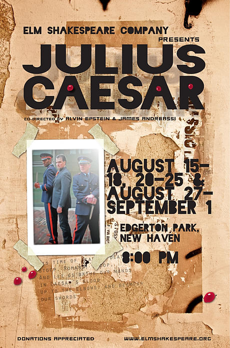
Which park? Edgerton Park. And if you didn't think we were going to throw a custom Google Map at you...
Just look down below. In fact, there's so much customized and arbitrarily utilized Google products on this website, that you might even see it on the Calendar, in fact automatically tweeted when we post it to the calendar.
If you were the Elm City Shakespeare Company person, you'd be amazed because this one #Nhv post covers nearly all the information on their webpage. What you're not going to find are links to their twitter. Just kidding. Actually, their web page is well-designed.
I suggest you take my advice, and go to see Julius Caesar in the park. Maybe I'll be there, if I weren't an imaginary character. All the imaginary characters will be on stage.
All week long at 8pm (August 27 - September 1). See NhvCal for details.
View Larger Map
Friday, August 23, 2013
New Haven Notables
Topics:
Maps,
New Haven Notables
 |
| This is Willowbee, a contributor to Nhv.org |
 |
| These are workers. Great construction footage! |
You can expect to see interesting photography and announcements to additions on the Vimeo.Com/Nhv channel here on Nhv.Org; This site aggregates news content from social media, as well as it produces some original content with our trusty intern, Willowbee. For more great maps, try NhvMaps. You can hope to get more information on how to produce your own customizable Google maps here on Nhv as we announce meet-ups to learn how to better use Google products.
View New Haven Notables in a larger map. You can add to this map with photos.
Sunday, August 11, 2013
How About Those Sidewalks
Topics:
Maps
View Sidewalk Descriptions in a larger map
Here is a map describing what you might see if you walk around town. It's a customized Google Map with embedded video. Anyone can make one! Try to zoom out and in with the map and see a variety of different patterns regarding the types of paved pedestrian pathways you might expect to see. We have brick paths, slate walkways, and then your standard typical cement sidewalk. Explore some of the other things you might see here.
For more maps, try the all-growing NhvMaps page.
Sunday, July 21, 2013
Track Amistad Here.
View Amistad KML Data in a larger map Current position, as of 11pm Sunday Night. View Amistad KML Data in a larger map
The Amistad, legendary ship full of African slaves who mutinied their Spanish captors, sailed arbitrarily to New Haven, Connecticut of all places, and were exonerated of all charges and sent back to their homeland, is making its way back to its home port. At 11pm currently the ship's location is in the Long Island Sound, just south of Old Lyme. [source]
If you should wake up at a very early time of day, you will see that ship enter the harbor. Estimates range between 5:30 and 6:30 AM. With the sun rising at 5:37, we anticipate perfect lighting.
Thursday, July 11, 2013
Instagram Geotagging on Nhv
Geography is important, and the world is based on places. People have homes, and 95% of homes are stationary. While people have a tendency to move, geographical places remain fixed in their position, and that's the importance of the hashtag #Nhv.
The growing list of people who use it can be found on both Instagram and Twitter. Their ranks are numerous! This map shows you people who have identified their photographs as "New Haven" via this three-letter code, based on the Amtrak station identification for New Haven, Connecticut.
The goal of this site? Hopefully to gather a better insight for what is really going on around here! As well, to solidify the context of our geographic region and to make access to Nhv.Org publicly available.
To post your pictures to this website, just tag it with #Nhv and it'll appear right here. Or there. Actually it will show up all over the place, on both the home and mobile versions of the site.
View the mobile version of the site to gather some insight into what is going on at the present moment, through its three major features:
1. Calendar of Events
2. Twitter #Nhv Feed
3. Instagram #Nhv Feed
4. Articles, such as this one.
You're encouraged to read the articles at a home computer or a desktop for the optimal experience. Embedded maps don't always appear to work properly on mobile cellphones, even if you have the one that is big enough for Shaquille O'Neal!
#Nhv is Latitude: 41°18
Sunday, March 31, 2013
Night Rainbow Vantage Points
Topics:
Maps,
SiteProjects
Are you excited for April's "Night Rainbow" from SiteProjects? It's a four evening art display which will be visible to tens of thousands of people for free on the weekend of April 24th. And it will be visible from dusk until about 1am.
People are already trying to determine where the best points to view the installation will be. Some have said that Phelps Triangle, across from Berzelius Society building, is a point of focus for the Night Rainbow. It's also been said that downtown positions of elevation, such as the parking structure that the Square with Four Circles installation was installed, will also be a good vantage point.
Check the map above. If you'd like to edit it yourself, and perhaps add a vantage point, simply click here and log in using your Google account. If you want to see it better, select "Ter" or "Map" from the top right corner. It is currently set to resemble a treasure map.
You can read more about the project by visiting the official site for the project, the site for the artist, or the site for the arts organization which is funding it.
See NhvMaps for other maps.
Sunday, February 24, 2013
Fueling the Arts at a Local Coffeeshop.
Topics:
Art Scene,
Coffeeshops,
Maps,
Videos

This month at Fuel, check out the artwork on display. It's actually pretty good. They're painted window panes and snare drums. Original ideas from one of the kids that work there.
He might even make you a latte. Or watch your response as you examine each one above the people sitting at the tables below. It's kind of a classic scene, when you think about it. The fellow who made the paintings said that music is his main form of expression, and that painting was a second thought. Not a bad second thought. This is his first art showing.
Not bad, for a first show.
The artist's name is Alexander Burnet and he's a member of the band The Proud Flesh. He's part of the Local Music Scene, as well as evidently the Art Scene. He's also a Barista who reminds me of Rinsey.
Few could pick a better spot to drink their coffee than here on Wooster Street. It's walking distance from the Saturday Farmers' Market, and it's a relatively quiet place to sit, drink coffee, have a conversation with an old friend, or make a new one.
Check out the local scene page for more information about the local music scene.
Wednesday, October 31, 2012
Happy Halloween
 |
| Photo Credit: @BenBerkowitz |
The New Haven Green was first used as a cemetery, until James Hillhouse decided that it wasn't the best place for kids to run around. He decided to remove the tombstones, which were relocated into the nearby Grove Street Cemetery, where they still remain. It's said that at the time, it was becoming a problem having the tombstones there.
If you ever want to see what the original burial ground looked like, just check out this recent video from March 2012, when Robert S. Greenberg spread the message to Occupy New Haven that they were occupying sacred ground.
Video of last night's event will eventually be assembled into a documentary about New Haven. In the meantime, here are a few photos to get you in a Halloween state of mind. It's likely that the body exhumed died from disease or natural causes. The prominent diseases at the time were smallpox and yellow fever. The body was buried underneath the tree, which had been planted in commemoration of Abraham Lincoln at the beginning of the 20th Century. Therefore it was no mystery to the police that clearly the cold case was closed. The meticulous efforts of the workers (an archaeologist from Yale, a forensics expert from the State of Connecticut, and police personnel to provide lighting assistance and crowd control), made for an interesting experience.
Scientist depicted is Gary Aronsen ’04PhD,manager of the Yale Biological Anthropology Laboratories.
This is the most likely path that James Hillhouse chose, when moving the headstones from the New Haven Green (lower icon) to the Grove Street Cemetery. No one is certain how ceremonious this was, but there is sure to be folklore surrounding this event for at least 100 years.
Sunday, September 2, 2012
New Haven's 35th Annual Road Race
(Written Sunday 9/2 and Monday 9/3)
Registration has just closed for the New Haven Road Race this year, and that means that 7,000 people signed up already. Lots of information on the official site, so it's suggested that if you're looking for more info, follow that [link].
The race occurs annually in New Haven on Labor Day.
From Wikipedia:
"The New Haven Road Race has hosted the USA 20K Championship every year since its inception in 1978. The race, which featured 1,200 runners in its inaugural year, has grown to include as many as 7,000 participants."
The race kicks off at 8:40AM.
Music Video from today's race.
Update: The Route for the Road Race has been Changed.
The 5K kicks off at Church and Chapel now. There were other changes not mentioned on their site, which were announced 10 minutes before the race. This map represents the previously established route.
View New Haven Road Race Map in a larger map
 |
| Doonesbury Cartoon by Trudeau, Yale '70 |
The race occurs annually in New Haven on Labor Day.
From Wikipedia:
"The New Haven Road Race has hosted the USA 20K Championship every year since its inception in 1978. The race, which featured 1,200 runners in its inaugural year, has grown to include as many as 7,000 participants."
The race kicks off at 8:40AM.
Music Video from today's race.
Update: The Route for the Road Race has been Changed.
The 5K kicks off at Church and Chapel now. There were other changes not mentioned on their site, which were announced 10 minutes before the race. This map represents the previously established route.
View New Haven Road Race Map in a larger map
Tuesday, August 28, 2012
Map Directory.
Topics:
Maps
Maps are now located at NhvMaps.
The Everything Map [Add to this Map]
Add things about your experiences in New Haven, including embedding photographs and video using this custom map.
If you have a local map with particular data, please send the link to nhv.org@gmail.com
Trees, Urban Gardens, Agriculture:
URI (Urban Resource Initiative)
NHLT (New Haven Land Trust)
Atwater (Community Garden List)
Food and Businesses:
Food Cart Locations
Book Stores
Coffeeshops
Pizza
Social Services
Volunteer Income Tax Assistance (United Way)
Public Utility Notification Service (SeeClickFix)
Utility Maps
SeeClickFix Interactive Public Utility Map
DOT Interactive Harbor Crossing
Activities
Cycling
Basketball
Miscellaneous
Sidewalk Project
For All Maps, click [here].
[Make Your Own Maps With Google]
